Introducing Google's AI Powered Virtual Satellite Imagery
Satellite imaging is used daily, offering scientists an almost real-time examination of our planet.
The complexity and volume of data generated have necessitated a solution to effectively connect and utilise differing datasets.
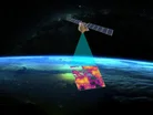
Google has responded with AlphaEarth Foundations, an AI-powered virtual satellite, designed to aid experts in making informed decisions on crucial environmental and developmental concerns.
Kate Brandt, Chief Sustainability Officer at Google, says: “Today we’re launching a new AI model, AlphaEarth Foundations, to help understand our planet in magnificent detail.
“Now, with just a few lines of code, researchers and governments can do complex analysis with machine learning to create maps for urban expansion, agriculture and clean energy planning.
“Groups like the United Nations FAO and MapBiomas are already using it to create powerful custom maps and drive real-world insights.”
AlphaEarth Foundations going to be useful?
AlphaEarth Foundations leverages AI to interpret the terrestrial and aquatic landscapes of Earth by synthesising extensive amounts of observational data into a cohesive digital simulation.
This gives scientists a comprehensive view of planetary changes, enhancing their capacity to address matters like food security, deforestation, urban growth and water management.
The technology distinguishes agricultural areas invisible to the unaided eye, employing RGB color-coding to further delineate complex environments, such as the notoriously hard-to-map Antarctica.

Tested by more than 50 organisations within the past year, the system has proven its real-world applicability.
Partners have reported substantial benefits, from categorising previously unmapped ecosystems to improving the precision and speed of environmental mappings.
Inside AlphaEarth Foundations
AlphaEarth offers a newfound perspective, tackling data overload and inconsistent information issues.
By aggregating data from various sources — optical satellite imagery, radar, 3D laser mapping and climate solutions — into high-resolution images, it tracks environmental shifts over time.
The software streamlines this information into concise summaries, with Google noting that it requires 16 times less storage than traditional AI systems, reducing costs for planetary analysis.
Rather than waiting for a satellite's next pass, scientists can now produce detailed maps on demand, monitoring vital areas like crop health and deforestation in real time.
Lila Ibrahin Chief Operating Officer at Google said on Linkedin: “For years, we've had vast amounts of satellite data, but it's often complex and disconnected.
“Our new AI model—Alpha Earth Foundations—can weave that data together into a single, detailed map, giving us an unprecedented understanding of our world.
“By enabling a more complete & consistent picture of our world, AlphaEarth Foundations has amazing potential to do things like:
• "Help researchers track deforestation
• "Empower communities to manage vital water resources
• "Enable easier monitoring of crop health to support global food security
“It’s powerful to see our research move from the lab to real-world applications that matter.
“Congratulations to the AlphaEarth Foundations team on this impactful work!”
Real world application of AlphaEarth Foundations
The Global Ecosystems Atlas is a prime example of AlphaEarth's potential, aiming to evaluate worldwide ecosystems by creating a comprehensive resource map.
It classifies untapped ecosystems, such as coastal shrublands and hyper-arid deserts, helping nations prioritise conservation, optimise restoration and curb biodiversity loss.
Nick Murray, Global Science Lead of Global Ecosystems Atlas says: “The Satellite Embedding dataset is revolutionising our work by helping countries map uncharted ecosystems - this is crucial for pinpointing where to focus their conservation efforts.”