How Microsoft is Saving Wetlands with AI Mapping and ML
Microsoft is throwing its weight behind an ambitious AI-driven effort to track down wetlands that are often overlooked.
Through its AI for Good Lab, the company is supporting TealWaters, a research group creating sophisticated mapping tools designed to locate these fragile ecosystems before they disappear completely.
The project carries real urgency.
Wetlands have been vanishing at a worrying pace, with more than 21% lost over the last 300 years, according to a 2023 Nature study.
The major drivers are urban expansion and intensive agriculture, both of which have long treated soggy landscapes as little more than land to be drained.
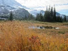
Yet wetlands aren’t easy to spot. Many are hidden beneath dense forest canopies or are otherwise camouflaged, making them difficult to identify with conventional mapping methods.
Old aerial photography – often grainy, black-and-white images – has long been the standard tool for agencies, but those pictures are now too limited for conservation work.
“Wetlands are super important ecosystems that provide a ton of functions for communities, but we don’t know where they are, what they’re doing and how to protect them,” says Meghan Halabisky, TealWaters’ Chief Scientist and a remote sensing expert at the University of Washington.
Microsoft’s role in the wetland hunt
Enter TealWaters’ answer: the Wetland Intrinsic Potential tool.
Think of it as a digital detective, piecing together evidence from aerial imagery, elevation models and water flow data – then applying machine learning to reveal the subtle signatures of wetlands that humans often overlook.
Behind the scenes, Microsoft’s Azure cloud platform is doing the heavy lifting, crunching massive datasets while the team experiments with computer vision and neural networks that can recognise wetland patterns faster and more accurately than before.
And the system goes beyond simple detection. It can estimate how much carbon a wetland holds, track ongoing ecological changes and even highlight areas where wetlands once thrived but have since vanished.
“Increasingly, we understand how vital wetlands are to a healthy planet,” says Juan Lavista Ferres, Microsoft’s Chief Data Scientist who runs the AI for Good Lab.
“TealWaters’ work plays a critical role in shaping a sustainable future and is a great example of how AI can help us better understand rich, diverse ecosystems.”
The technology is already being put to work.
The Tulalip Tribes of Washington state are using the tool to map wetlands across their ancestral territories, helping restore landscapes critical for foods like huckleberries and for sustaining salmon populations.
Steve Hinton, a conservation scientist with the tribe, says: “Much of the tribe’s culture relies on its reciprocity with the land and you have these beautiful wetlands that are biological hotspots for so many different species.”
He adds that “The tool helps us understand moisture on the landscape in a way that’s crucial for our cultural and environmental resilience.
“AI enables us to go through those mountains of information, helping us manage our lands and tell our story more effectively.”
Why Washington is becoming an AI testing ground
For its pilot, the team has chosen Washington state – a smart testing ground thanks to its diverse mix of ecosystems, from temperate rainforests to open grasslands.
The variety makes it an ideal place to pressure-test algorithms that could one day be applied worldwide.

The project is producing Washington’s first high-resolution wetland map, with a special focus on carbon-rich peatlands and dense forested wetlands – two types of ecosystems that are notoriously difficult to detect from the air.
And the benefits extend beyond Indigenous communities.
Smaller cities, often lacking in-house wetland expertise, are finding the tool transformative for land-use planning.
Instead of paying costly consultant fees just to identify wetlands and decide how to protect them, local planners now have access to precise, AI-driven insights.
“There are folks like the Tulalip Tribes using this tool to broadly ask how water is held across the landscape and where wetlands can be restored to store water longer through the season,” explains Maureen Ryan, who leads TealWaters’ multidisciplinary team.
The work is global in scope, bringing together collaborators from the University of Washington and TerrainWorks, a California-based geospatial company.
Microsoft is also providing a boost by opening access to its Planetary Computer platform, which stores vast troves of environmental data.
“We’re working with Microsoft to see how we can improve our models with deep learning and make the tool scalable and easy to deploy for different communities,” Meghan says.
Mark Newell, TealWaters Business Development Lead, says: “When you drain a wetland, we often don’t realise what we lost, because the land kind of looks the same and feels more ‘useful’.
“But wetlands are a giant battery for all this habitat, carbon, water and cooling.”